


Naburiya Synagogue and Nitzana Farm
A little archaeology: Remnants of the magnificent Naburiya synagogue in the Biriya forest and remains of the Nabatean city in Nitzana
In hidden corners of the JNF forests and sites throughout Israel, sprouting alongside tree roots, there are also other, historical, roots, which tell the story of ancient Israel.
In recent years the JNF with the assistance of the Antiquities Authority has opened and upgraded dozens of archaeological sites and prepared them for visitors. Today we will discuss two of the sites: The Naburiya synagogue in the Biriya forest and the Nitzana farm in the northern Negev mountains.
The remnants of the beautiful Naburiya synagogue rest along the scenic road of the Biriya forest, which is around 12 kilometers long. It is a high quality dirt path, part of which is paved with asphalt. Along the path there are numerous sites, but we will focus on the ones connected to the ancient settlement of Naburiya.
Naburiya Spring
The spring of the ancient Naburiya settlement flows from a small cave, located in the heart of a large and sparkling area of white chalkstone. Arches were carved which were used to provide drinking water for sheep as well as for doing laundry. The JNF built terraces, planted orchards and turned it into a beautiful area. The steps next to the spring lead to a romantic bench. In the winter you can observe salamanders.
A Lime Furnace
On a slope west of the spring there is an old lime furnace. The lime furnace walls have been reconstructed to a height of four meters. The lime furnaces in ancient days held great importance. The lime, which was created by burning the chalkstone, was used to plaster the water pits and to ensure that the water did not evaporate or seep out. The lime also protected the walls of the houses from erosion due to rain.
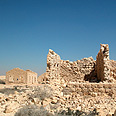
Naburiya Synagogue
The Jewish settlement in Naburiya existed during the first and second temple periods. Archaeological excavations uncovered the remains of the village’s magnificent synagogue, one of the oldest in the Galil. The first synagogue at the site was enlarged during the third century, apparently due to the expansion of the settlement; it was later destroyed in an earthquake in 363 C.E.
The settlement continued for 200 years, and in 564 they rebuilt the synagogue. The exact date is known from the inscription that adorned the central doorpost: “Built four hundred and ninety four years after the destruction of the temple under the leadership of Hanina ben Lizar and Luliana bar Yuden”.
This inscription is very important. The inscription announces that the synagogue was built 494 years after the destruction of the temple, during the leadership of Hanina ben Lizar and Luliana bar Yuden, when they were heads of the community or synagogue. The mentioning of dates in synagogue inscriptions is very rare. The inscription is displayed today at the Israel Museum.
The synagogue building stood until approximately 640 C.E. At the site today there are two rows of four columns. The façade of the synagogue was partially reconstructed by the JNF and Antiquities Authority.
How do you get there?
The scenic route in the Biriya forest is marked with green arrows. The route begins on the Rosh Pina- Kiryat Shemona road, slightly north of Machanayim Junction (Road 90, between the 443-444 kilometer marking) and ends south of Moshav Dalton (Road 886, between the 41-42 kilometer marking). The Naburiya synagogue is located in the middle of the route, slightly west of Amuka.
Nitzana Farm
In the Negev there is not enough precipitation to grow agriculture watered by rain on the slopes of the mountains. And yet, in ancient days the inhabitants of the Negev showed resourcefulness and successfully worked thousands of dunams of land. They overcame the lack of water by collecting rain water flowing down the slopes and transferring it to the fields.
This method commanded three principles: The land had to be in the valleys, in areas lower than their surroundings. The water was collected in channels and transferred to the fields. All parts of the field were enclosed by a dam, which stopped the water, which they used to irrigate the crops.
The excess water that collected in the upper parts, topographically speaking, would stream down to the lower parts. The run-off agriculture in the Negev began to develop during the Iron Age and maybe even before then, and reached its peak during the Byzantine age.
Remains of the Nabatean Nitzana
Nitzana is the westernmost Nabatean city in the Negev. The city overlooks the road that leads from the Beer Sheva valley to Sinai, and it filled an important position as a station on the road for pilgrims to Mount Sinai. Man first settled here in 3 B.C.E, when the first Nabateans came to the Negev. The city was abandoned and then settled again in 3 C.E.
The settlement in ancient Nitzana was located in the upper city (acropolis), which was on top of a hill, and in the lower city that sprawled along the western foot of the hill. At the end of the third century a large fortress was built at the top of the hill, which occupied most of the summit of the hill.
North of it, on the remains of a more ancient fortress, a church dedicated to Sergius and Bacchus, was built during the beginning of the Byzantine era. On a hill south of the city, another church was built in the seventh century for Saint Maria. At the foot of Nitzana the remains of an additional church were found.
The excavations at Nitzana revealed an amazing discovery: 195 papyri including documents and selections from church literature. The papyri also mentioned the name of the settlement in those days - Nessana.
In 1908-1915 the Turks, with the help of the allied Germans, built a large administrative center, called Auja-El-Hafir, the Arabic name for Nitzana. At the top of the acropolis they built a large building, which served as a hospital and hostel. South of the tel they established a street of administrators’ homes, some of which still remain. At the beginning of World War I, the Turks built railroad tracks and a station house, from which a large pool of water remains.
The farm at Nitzana
In 1990 the JNF together with the youth village at Nitzana began to rehabilitate the agricultural farm, one of many which functioned during the Byzantine era at Nitzana. Old terraces stood on the shallow valleys, and between these area slopes were put in to carry the additional water. After this, they planted orchards of pomegranates, figs, olives and carobs. The farm also serves as an educational site for the students at the youth village at Nitzana.
There are years when there is one run-off agriculture event, and there are years when there are four or five, but sometimes there can be a few years without any events. In any case, from the experience acquired at the Nitzana farm, you can learn about the possible potential in rehabilitating the ancient agricultural terraces in the Negev, not for agricultural purposes but to preserve tradition, tourism and animal life.
How do you get to the reconstructed farm?
From the youth village travel two kilometers in the direction of Azuz. Turn right on a paved and bumpy road and drive 1.1 km. Turn right again and after 400 meters you will reach the farm.