


Map of Hezbollah sites
מתוך אתר הוושינגטון פוסט
Israel releases map of Hezbollah bunkers in Lebanon
Washington Post obtains map detailing bunkers, arms caches, surveillance sites in south Lebanon. IDF official: We want to show world that Shiite group has turned villages into fighting zones
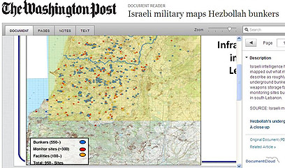
An Israeli security official provided the Washington Post with a map detailing no less than 550 bunkers, 300 surveillance sites and 100 other facilities the Jewish state believes belong to Hezbollah terrorists in Lebanon.
Most of the sites marked on the map, which appeared in the American newspaper on Wednesday, are located south of the Litani River.
Ten arms caches are marked on another map featuring an aerial view of the Al Khiyam village in south Lebanon. The weapons storage facilities are located in close proximity to medical centers and schools.
According to the map, one of Hezbollah's bunkers is located in a mosque.
"In releasing the map, the Israeli military appeared to be trying to preempt international criticism of any future offensive against the alleged sites, many of which are located in residential villages alongside hospitals, schools and even civilian homes," the Post reported.
The daily quoted a senior Israeli commander as saying, “Our interest is to show the world that the Hezbollah organization has turned these villages into fighting zones.”
About six months ago then-IDF Chief of Staff Lt.-Gen. (res.) Gabi Ashkenazi warned that Hezbollah was establishing "rocket villages" in south Lebanon, adding that the Shiite group was using civilians and UNIFIL's lack of authority to act in order to fortify its positions and rocket launchers inside the villages.
- Follow Ynetnews on Facebook