US publishes satellite images of Syria mass graves
Government website releases photos said to be showing mass graves, artillery impact craters near civilian areas
A US government website on Friday published what it said was photographic evidence of mass graves and attacks on civilian areas by Syrian government forces.
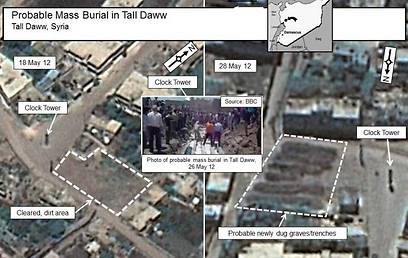
The website, operated by a bureau of the State Department, published a series of overhead photos, said to be taken earlier this week by commercial satellite, showing what it said were mass graves dug following a massacre near the town of Houla.
Related stories:
- Iran's leader urges punishment for Syria massacre Syria: Anti-gov't groups committed Houla massacre UN: Syria forces may face prosecution for attacks
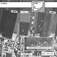
They also showed apparent artillery impact craters near civilian areas of a town called Atarib.
Included on the web page are pictures which apparently show artillery deployed as of May 31 near three Syrian towns and attack helicopters allegedly deployed near the towns of Shayrat and Homs.
The pictures are credited to commercial satellite imagery companies.

Images of mass graves? (Photo: Reuters)
More than 100 men, women and children were massacred in Houla last week, most of them shot at point-blank range or slashed with knives.

Attack helicopter at airfield (Photo: Reuters)
UN peacekeeping chief Herve Ladsous said earlier this week that the people who died from artillery and tank fire were clearly victims of government shelling while the others were most likely killed by "shabbiha" militia loyal to President Bashar Assad.

Artillery shelling (Photo: Reuters)
Damascus has blamed the massacre on the opposition, which Assad has tried unsuccessfully for 14 months to crush, killing over 10,000 people in the process, according to the United Nations. Russia, which has used its veto powers to prevent the UN Security Council from sanctioning Syria, blames Islamist militants for the Houla massacre.
The State Department website highlights what it said are before and after satellite pictures showing mass graves near Houla.
A May 18 photo from Tall Daww, a village near Houla, shows what the government says is a square that appears to be a flat dirt clearing. Juxtaposed against this is what the US government says is a May 28 photo of the same square with what appear to be rows of turned up earth, which is labeled as "probable newly-dug graves/trenches."
- Receive Ynetnews updates directly to your desktop


