


'Breast clouds' over Israel
Dry air under high, thick clouds formed uniquely shaped clouds all over the country during spring heatwave.
Israel's sky was covered Saturday with mammatus, also known in their popular name "breast clouds," following the heat wave in the region.
Professor Hadas Saaroni, a climatologist from Tel Aviv University explained how these uniquely shaped clouds are formed.
"They get this shape when clouds are formed in an altitude of four kilometers. Under this higher layer of air there is air that is rather dry. When these clouds rain onto a dry layer, the rain instantly evaporates and the round shape of these clouds is formed.
"While most of the rain doesn't make it to the ground because it evaporates on the way down, the rain that does penetrate through washes the dust that came in with the winds, and turns into mud-rain," Saaroni explained.

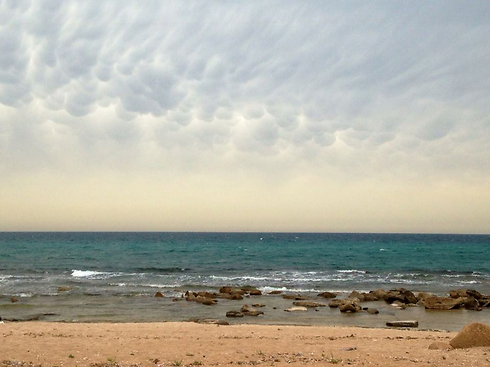


Shlomo Uberman, of Meteo-tech meteorological services, added that "these clouds are created as a result of an active jet stream which is currently taking place in our region and causing rainfall. An active jet stream is a flow of medium and high altitude winds. These clouds can be usually seen during
transition seasons."