


New year rain follows driest December in 18 years
Despite first days of new year seeing heavy rains from north to south, nature plays catch-up to compensate for driest December in almost two decades.
According to the Israel Meteorological Service, the amount of rainfall in December in most parts of the country has been half of the average for the month in previous years. The dearth of rain was particularly noticeable in the Kinneret area, where only 20-30mm of rain fell in December—less than a third of the monthly average.

The driest December in almost two decades joins the arid months of October and November, with cumulative rainfall since the beginning of the season and until the end of December being less than the multiyear average of previous seasons.
The northern mountains and the central and southern Coastal Plain saw only half of the average precipitation for the season. The northern Coastal Plain, the Carmel and the Western Galilee fared somewhat better, where cumulative rainfall reached 65-75 percent of the season's average.

December was also characterized by relatively few rainy days, causing the beginning of the rainy season to be significantly diminutive. The final month of 2017 was also hotter than average, a fact especially evident in the daytime, with temperatures two or three degrees (Celsius) higher than average. In the past 70-75 years, in fact, only two to four Decembers were hotter in the daytime, with the last occurrence of such a phenomenon taking place in 2010.
Dr. Amos Porat of the Meteorological Service said another arid winter was in service's yearly forecast, but surprises may still occur. "In fact, it will suffice to experience only a handful of rainfall to fill in the gap, average-wise. It may yet happen," he said.
The problem with the last decade and even longer, Porat said, was not merely the scant amount of precipitation but also the absence of any years with higher than average rainfall.
"In previous decades, we'd have an especially rainy year once or twice a decade—as we did in 1991-1992 or 2002-2003. A year like that would fill in the gap. In the past 15 years, however, we've had years with fewer than average rainfall, some average years and years with higher precipitation than average—but not as significantly as we did before," he lamented.
A warm winter
December was indeed not merely lacking in rainfall but bountiful in heat. Daytime temperatures were higher than the 1995-2009 average in northern and central Israel by 2-3 degrees and by 1-.5-2.5 degrees in southern Israel. Nighttime temperatures showed a different trend, with southern and mountain temperatures higher than average by 1-2 degrees, higher by 1 degree in the Coastal Plain and about average in the northern valleys.
Compared to the past, this past December was also one of the hottest on record as far as daytime temperatures go in northern and central Israel. In the past 70-75 years, hotter December temperatures were measured in only between two and four past instances—in 2010 and 1960, and in some regions in 1990, 1952 and 1950.

Most of the days in December showed higher than average temperatures, especially in one two-week long stretch between December 10 and 23, which also saw hardly any rain.
Temperatures during that period were higher than average by 6-7 degrees in the daytime in the mountains and inland and by 4-5 degrees on the Coastal Plain. On some days, maximal temperatures reached as high as 27-28 degrees in the Coastal Plain, the Shfela, the Negev and the Arava.
Nighttime temperatures during that two-week stretch were also higher than average, albeit by a smaller margin.
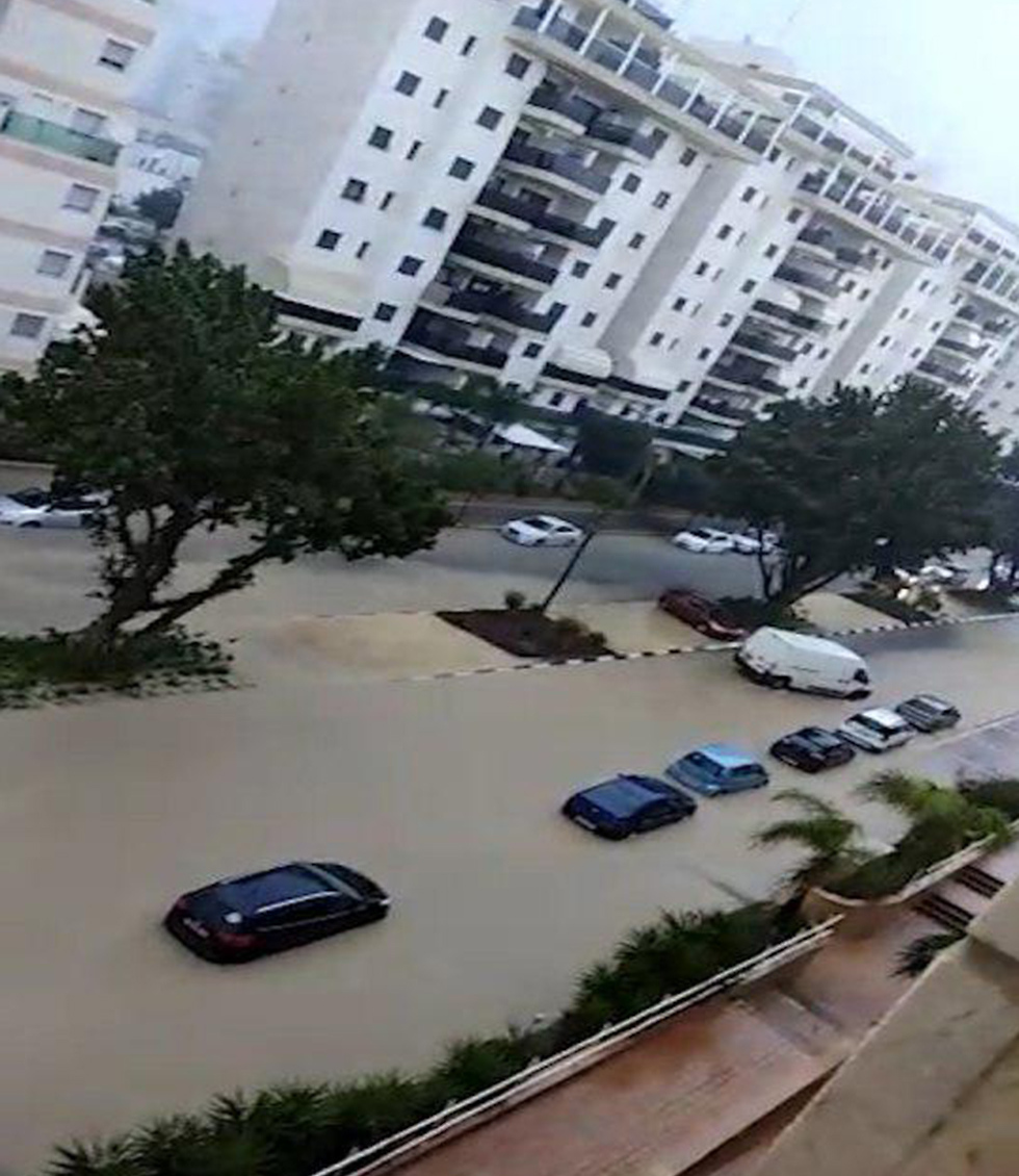
Despite such poor tidings in December, January seems to be off to a different start with rain in forecast throughout the first week of 2018. Rain is expected to continue Wednesday morning, before returning with what is expected to be a lashing storm on Friday.
The current wintery weather will continue on Wednesday. On Thursday, rain will pick up ahead of the real storm which will hit on Friday. The Lachish region (Kiryat Gat) has so far seen the most rainfall with 57 mm.
Meteo-tech weather forecasting station reports that during the last few days, 53mm of rain have fallen in the northern Golan Heights; 41mm in the northern Galilee; the Haifa region experienced 38mm; Zichron Yaakov, 34mm; 30mm in the lower Galilee (Nazareth area); 30mm in the Tel Aviv metropolitan area and 29mm in the Jezreel Valley.
The Hula lowlands received 29mm of rain; Bat Yam, 27mm; Ashdod, 27mm; Ashkelon, 24mm; the central Golan Heights, 24mm; Jerusalem, 23mm; Rishon LeZion, 18mm; Beer Sheva, 10mm and Arad 9mm.
The Mt. Hermon site is open to visitors for free. The ski lift is operating but due to weather conditions, only for those above the age of 5. The weather there is hovering around 0 degrees Celsius with heavy fog. On the upper slopes the snow has reached 25cm while on the lower slopes, 12cm.

Weather forecaster Tzachi Waxman from Meteo-tech pointed out the interesting phenomenon that during the night after the rains, temperatures rose higher than during the daytine. In Tel Aviv Monday it was 12 degrees while at night the temperature rose to 16 degrees. In Jerusalem, the night temperature rose from 6 to 9 degrees Celsius.
Wednesday is expecting some sunshine and an increase in temperatures. The rain will return Thursday morning, especially in the north and then spread towards the center of the country accompanied by thunderstorms. Snow will fall on the Hermon and winds are expected to pick up.

Friday will be considerably stormy and winds are expected to gather speeds of 90-100 km an hour. The waves on the Mediterranean shore will reach a height of seven meters, nudging authorities into setting up a flood watch. Mt. Hermon is expecting heavy snowfall and in the south there will be sand storms and low visibility. The weather is expected to calm and stabilize by late Friday evening.
Massive water shortage in the Kinneret
The water level in the Kinneret rose a half centimeter reaching -214.36 meters below sea level. It still needs another 5.56 meters for the lake to be considered full.
The plight of the Kinneret is especially dire, this being the fifth consecutive year of insufficient rainfall. Natural water sources are lacking more than 2.5 billion cubic meters of water (900 million for the Kinneret alone).
In December 2017, the Kinneret water level remained the same despite the fact that most years it rises an average of 20 cm in December. Lately, due to the water shortage, hardly any water is pumped out of the Kinneret into the National Water Carrier.
On average, the Kinneret rises 30cm during January and since the beginning of the year it has risen 1.5cm. Next weekend's rainfall is expected to help raise water levels, but considering that the last few years have been relatively parched, water reserves are in severe deficit. Only two months of intense rains can fill the gap.