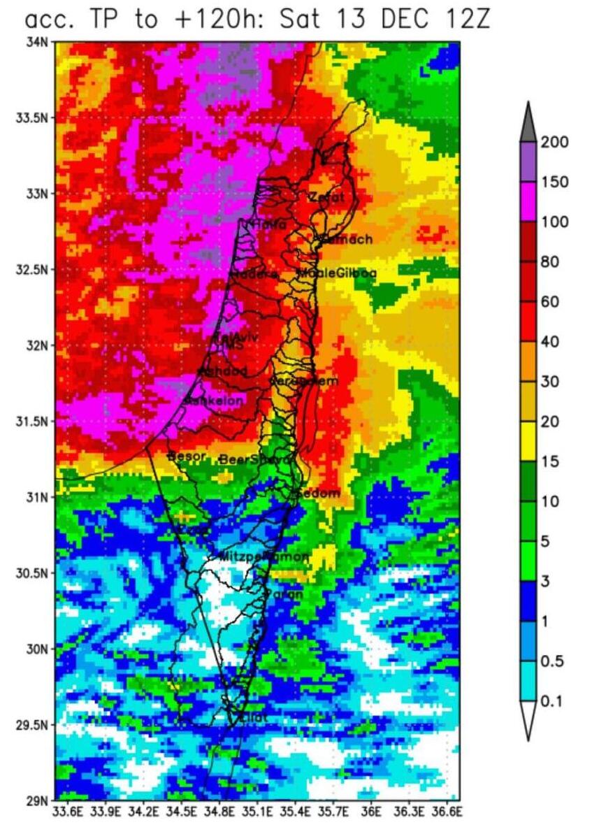
Storm Byron will begin affecting Israel in earnest Tuesday, with the worst expected overnight Wednesday into Thursday. Meteorologists warn that up to 200 millimeters of rain may fall overall — including dozens, possibly up to 100 mm, over just a few hours.
Rain in Tel Aviv overnight
(Video: Rami El)
Rain began Monday night, but the main storm front is only just arriving. Byron is forecast to hit on Wednesday, affecting large parts of northern and central Israel. Coastal cities and the Sharon plain may see flooding; flash floods are also a concern in the wadis of the Judean Desert, as the storm is expected to bring very heavy rainfall in short bursts.
Overnight the rain was modest but widespread: the highest rainfall recorded was 15.7 mm at Kibbutz Bahan in the Emek Hefer area. Other notable measurements included: 14.7 mm in Ein HaHoresh, 13.8 mm in Ahituv, 13.1 mm in Midreshet Ruppin, 11.4 mm in Lehavot Habashan, 7.7 mm in Herzliya, 7.3 mm in Hadera, 7.2 mm in Gilad, and 6.6 mm in Tel Aviv.
Tuesday’s outlook
Expect partly to mostly cloudy skies with temperatures close to seasonal average. Local showers and isolated thunderstorms are forecast along the coastal plain, especially in the north. During the afternoon, light rain could spread across much of the country, with more substantial rainfall and thunderstorms expected overnight, mainly along the coast and Sharon plain. Flooding is possible, with strong winds developing and rain gradually extending into central and northern Israel.
What to expect in the coming days
Wednesday–Thursday: Widespread heavy rain and thunderstorms are expected across central and northern Israel. Coastal plain and Sharon are at particular risk for flooding. Winds may strengthen significantly along the coast and in higher terrain. Rain may spread gradually as far south as the Negev. In the Judean Desert and the Dead Sea region, there is a real danger of flash floods.
Thursday: Rain will continue intermittently, accompanied by possible thunderstorms from the north down to the northern Negev. In southern Negev, local showers are possible, with ongoing flood risks in the Dead Sea area and the northern Arava. The coastal plain and Sharon may also see further flooding; winds will remain strong and temperatures will stay below seasonal norms.
Friday: Local showers will persist from the north to the northern Negev. Isolated storms are still possible into the afternoon. Flooding remains a concern along the coastal plain and in wadis of the Judean Desert and Dead Sea region. Temperatures will rise slightly but will remain somewhat below seasonal averages, especially in the mountains and inland areas.
According to the national weather service, the peak of the storm may bring winds of 80 km/h–100 km/h, heavy rainfall amounts over a short period, city flooding, disruption on roads and flash floods in the desert and Dead Sea wadis. Overall rainfall during Byron is expected to far exceed typical December averages for coastal and central Israel.
“Most people will see the full impact by Thursday morning. The emphasis is on extremely large precipitation totals — all of December’s rain in one day," according to Dr. Amir Givati, director of the Israel Meteorological Service. "We expect heavy and intense bursts of rain, especially over Gush Dan and the center, coastal areas and the Sharon plain. Roadways are especially vulnerable; drainage and pumps must be ready. This is a prolonged event.”
Temperature Outlook (Tuesday / Tuesday night):
Jerusalem: 9–16°C
Tel Aviv: 13–19°C
Haifa: 14–17°C
Safed: 9–12°C
Katzrin: 11–15°C
Tiberias: 13–17°C
Nazareth: 12–16°C
Afula: 13–20°C
Beit She’an: 13–20°C
Lod: 12–20°C
Ashdod: 13–20°C
Ein Gedi: 14–18°C
Beersheba: 11–19°C
Mitzpe Ramon: 9–14°C
Eilat: 15–20°C
(A


