Winter finally arrived in force across Israel, bringing significant rain, flooding and even a double rainbow captured over central districts. The storm system that began affecting parts of the country on Thursday strengthened overnight, with heavy rainfall continuing into Friday after hail was recorded in several areas.
Starting around 5:30 a.m., intense rain fell along the Mediterranean coastal plain between Hadera and Ashkelon. By 7 a.m., Ashkelon had recorded the highest rainfall in the country with 66.3 millimeters in the past 24 hours, leading to flooding across the city. Eight people were rescued from vehicles but were not injured.
Rescue of a couple from a car that was submerged in Ashkelon
(Video: Israel Fire and Rescue Services)
“Waterfall” inside a supermarket in Acre
(Video: Sarah Amir)
In the Tel Aviv metropolitan area, the light rail system was halted for about an hour and a half because of weather-related power outages. Hadera saw 41.1 millimeters of rain along with heavy hail, while Acre measured 35.4 millimeters. Even Sodom, near the Dead Sea in the south, recorded 5.7 millimeters of rain in the past day.
According to the Israel Meteorological Service, rain reached central cities overnight. As of 7 a.m., one Tel Aviv station measured 32.3 millimeters, and Raanana received 6.5 millimeters. Jerusalem’s Givat Ram station measured 7.6 millimeters, while Lod recorded 8.2 millimeters, Haifa 2.6 millimeters and Ariel 0.6 millimeters.
Lightning strikes in Ashkelon
(Video: Maxim Hanin)
Heavy rainfall and significant flooding are expected throughout the day in central Israel, especially along the coast from Tel Aviv to Ashkelon. Localized showers are forecast in the north and center, along with thunderstorms. Parts of the northern Negev are expected to see scattered rain. Beginning in the afternoon, forecasters warn of a slight risk of flash floods in the desert canyons of the Judean Desert and around the Dead Sea. Temperatures will drop sharply and remain below seasonal averages.
Rain will continue intermittently overnight between Friday and Saturday in northern and central Israel, still accompanied by thunderstorms and a continued risk of flooding along the coastal plain and lowlands. The northern Negev may see scattered showers, and the flood risk in desert canyons will persist.
8 View gallery


Rescue of a couple from a car that was submerged in Ashkelon
(Video: Israel Fire and Rescue Services)
Forecast temperatures for today and tonight (Celsius):
Jerusalem 12–19, Tel Aviv 16–21, Haifa 16–20, Safed 12–17, Katzrin 14–20, Tiberias 17–24, Nazareth 15–19, Afula 15–23, Beit Shean 18–24, Lod 15–21, Ashdod 14–20, Ein Gedi 17–24, Beersheba 15–21, Mitzpe Ramon 12–17, Eilat 18–26.
8 View gallery


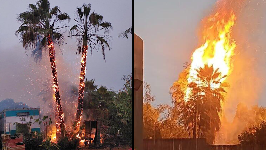
The palm trees that caught fire in Binyamina
(Photo: Per Section 27a of the Copyright Law)
On Thursday night, palm trees caught fire on Carmel Street in Binyamina after lightning apparently struck a nearby structure. Fire and Rescue Services said the blaze threatened a nearby trailer, but crews extinguished the flames. Flooding was also reported in Pardes Hanna and at the northern entrance to Or Akiva. According to meteorological data, 9.6 millimeters of rain fell within one hour at Hadera’s port station during the afternoon.
On Saturday, scattered showers are expected again in northern and central Israel. Thunderstorms are possible until midday. Forecasters warn of a continued slight risk of local flooding along the coastal plain and flash floods in the Judean Desert and Dead Sea region. Temperatures will remain slightly below average.
On Sunday, partly cloudy to cloudy skies are expected with occasional light rain from northern Israel to the northern Negev. Rain will taper off gradually in the afternoon. Temperatures will remain slightly below normal before rising slightly on Monday. Monday is expected to be partly cloudy with temperatures returning to seasonal norms.


