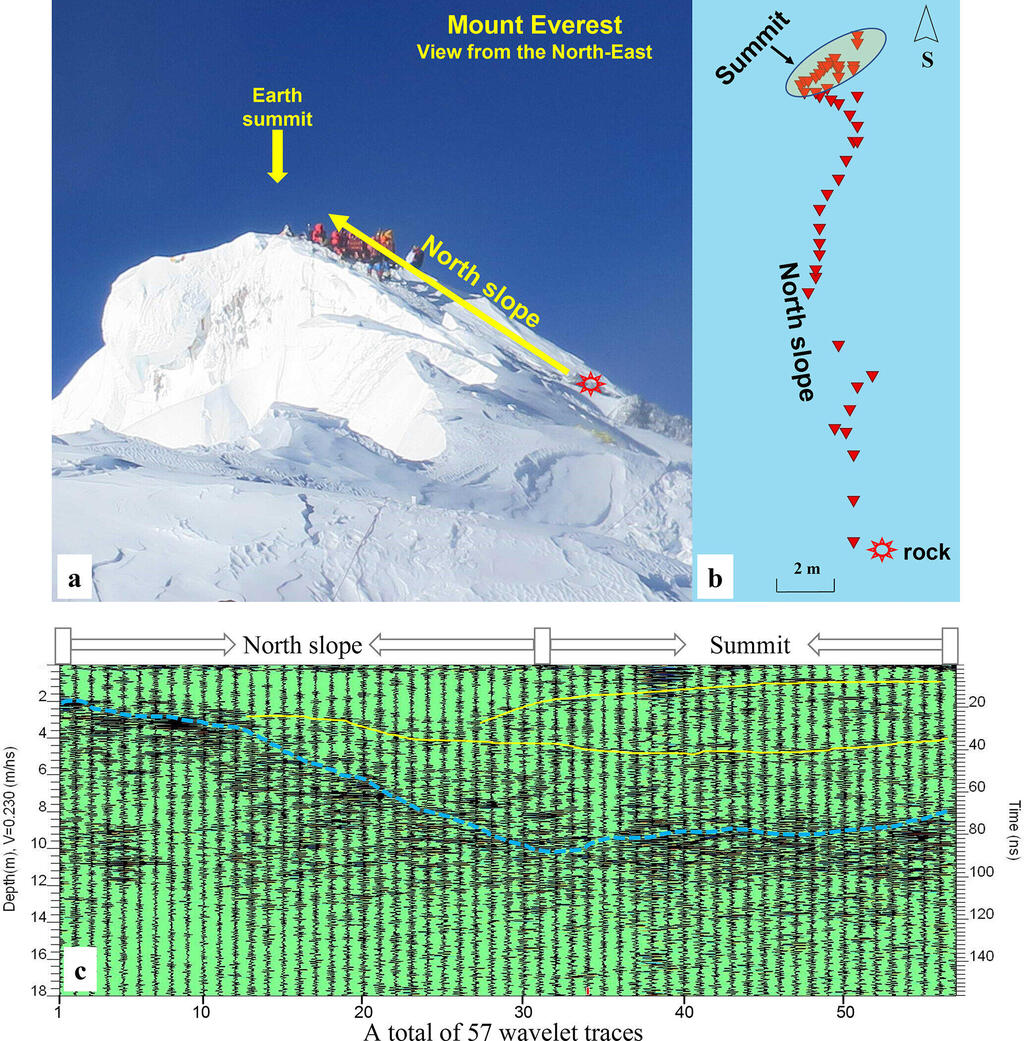
The Second Tibetan Plateau Scientific Expedition and Research (STEP) team has made a significant breakthrough in understanding the average snow depth on Mount Qomolangma (Mount Everest). Through their innovative use of ground-penetrating radar (GPR) technology, the researchers implemented a novel approach.
Read more:
They began their measurements from exposed limestone at a lower elevation point, leading to highly precise readings. Utilizing this new method, the scientists determined that the snow depth at the summit is approximately 9.5 ± 1.2 meters, which significantly differs from previous estimates ranging from 0.9 to 3.5 meters.
During the "summit mission" of STEP conducted between April and May 2022, the team collected the data to obtain accurate measurements of the snow depth on Mount Qomolangma. They utilized a Sensor & Software Pulse EKKO Pro GPR system, which is a system equipped with a single transmitter-receiver antenna, specially modified to withstand the extreme conditions of Qomolangma. This adaptation ensured precise readings of the snow depth at the summit.
Prof. Yang Wei, the study's lead author and a researcher from the Institute of Tibetan Plateau Research of the Chinese Academy of Sciences, emphasized the value of the new method: "Our innovative approach allowed us to discern more accurately the boundaries between the snow and rock, refining our understanding of the actual rock height of Mount Qomolangma beneath its snowy summit."
2 View gallery


Radar measurements along the north slope of Mount Everest
(Photo: The Cryosphere (2023). DOI: 10.5194/tc-17-2625-2023)
The significance of this research, which was published in the Cryosphere, extends beyond merely measuring snow depth on Mount Qomolangma, as highlighted by Prof. Yao Tandong, the expedition's chief scientist. He emphasized that this finding provides a gateway to deeper insights into our planet and the effects of climate change at high altitudes.
The snow depth on Mount Qomolangma serves as a crucial indicator of climate conditions. Variations in snow accumulation and drifting, influenced by weather patterns, have a substantial impact on the overall snow depth. With the improved measurement obtained through the innovative radar method, scientists now have an opportunity to further investigate snow stratigraphy and snowpack properties at the summit.
Prof. Yang Wei also said the STEP team plans to continue utilizing this advanced radar technique to study snowpack characteristics on Mount Qomolangma. These ongoing studies will contribute to a more precise understanding of the consequences of human-induced climate change on the Earth's most extreme environments.


