
In today’s technological world, information is no longer just power—it is a critical survival tool. While Israel’s air defense systems work to physically intercept threats from Iran and Lebanon, a parallel battle is being fought on the digital front, focused on making information accessible to the public.
Over the past two years—and especially during the events of the past year involving Iran and its proxies—demand has surged for “data aggregator” systems: platforms that collect, analyze and display security threats in real time on interactive maps.

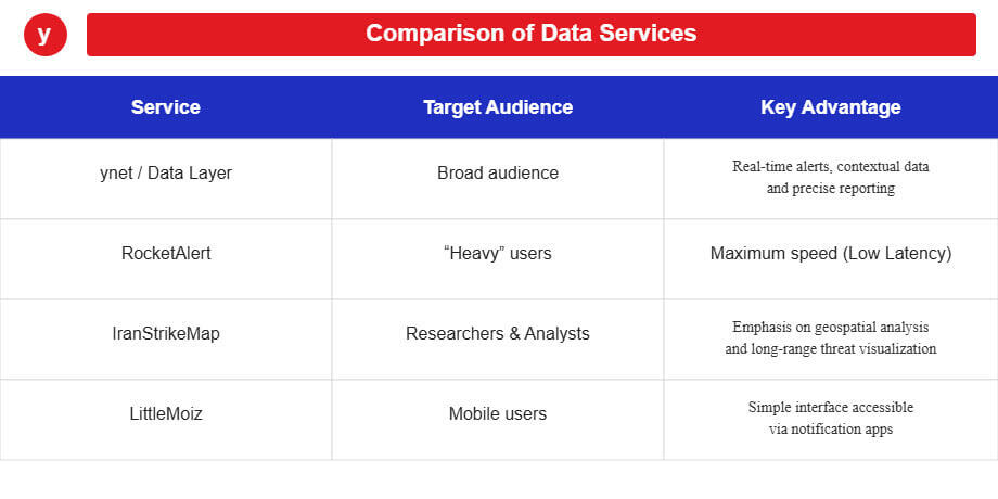
An ecosystem of alerts
Israel’s market, which has effectively become the world’s largest testing ground for warning technologies, now offers a wide range of solutions. On one side, established media organizations such as ynet have integrated advanced data components that allow users to access geographical and quantitative information about air raid sirens.
On the other side, independent initiatives have emerged, including RocketAlert.live and LittleMoiz, which offer lightweight, fast interfaces with virtually zero delay, along with deeper data such as interception counts and impact locations.

A global look shows that the trend is not limited to Israel. In the United States, platforms like Liveuamap have become a standard tool for covering conflicts, using artificial intelligence to filter false reports. In China, technology giants such as Baidu have integrated security information layers into civilian navigation apps, with an emphasis on emergency management and civilian evacuation.
In Europe, websites such as FlightRadar24 have begun displaying GPS disruption data, which can serve as an indirect indicator of military activity in areas of tension.
The war over the signal
The skies above the Middle East are not only a battlefield for missiles—they are also an invisible electromagnetic battlefield. One of the main factors affecting the accuracy of these maps is GPS warfare.
To remain reliable, mapping systems must contend with two primary types of disruption:
Jamming: the transmission of strong electromagnetic noise that disables receivers. Systems detect this when “black holes” of data appear in certain areas.
Spoofing: a sophisticated technology that broadcasts a fake GPS signal. The receiver is tricked into believing it is in a different location—for example, an aircraft over Lebanon that “sees” itself at Beirut airport.
Modern data systems can now expose this kind of military deception using crowdsourced intelligence. They compare the satellite-based position reported by an aircraft with the location detected by ground radar. If there is a discrepancy, the system marks the area as compromised and warns users.
From the telegraph to the digital map
The technology underlying these systems—GIS (Geographic Information Systems)—has come a long way. In the past, cross-referencing intelligence data on a map was the exclusive domain of military command centers. In the 1990s, such systems required enormous computing power.
Over the past decade, however, the open-source revolution has transformed the field. Code libraries now allow developers to build a “digital command center” within hours.
At the same time, a major shift in public perception has taken place. During the 1991 Gulf War, the public relied on radio broadcasts for warnings. By 2026, control has shifted to the user. Technology has evolved from merely reporting events to predicting them, with systems capable of calculating danger polygons based on wind data and launch angles.
Ultimately, the demand for these tools stems from a “thirst for information” created by uncertainty. Today’s users are no longer satisfied with simply hearing an air raid siren—they want to see the raw data with their own eyes.
As threats become more complex, the need will grow for alternative navigation and mapping systems that do not rely solely on satellites such as GPS or GLONASS, but instead incorporate artificial intelligence and image recognition.